The Gates of the Rocky Mountains.
Sandra L. Arlinghaus, Robert J. Haug, and Ann E. Larimore
The University of Michigan
The historical texts of Meriwether Lewis, Captain United States Army, and William Clark, Captain United States Army, offer the mind's eye a stunning visual scene of explorers navigating a walled passage along the Missouri River, through the Rocky Mountains, just upstream from what is now Great Falls, Montana.
-
Journal
Entry: July 19, 1805
-
Quotation
from Lewis [DeVoto, pp. 159-160]:
-
this morning we set out early and proceeded on very well tho' the water
appears to encrease in volocity as we advance. the current has been
strong
all day and obstructed with some rapids, tho' these are but little
broken
by rocks and are perfectly safe. the river deep and from 100 to
150
yds. wide. I walked along shore today and killed an Antelope.
wh[en]ever
we get a view of the lofty summits of the mountains the snow presents
itself,
altho' we are almost suffocated in this confined valley with heat. this
evening we entered much the most remarkable clifts that we have yet
seen.
these clifts rise from the waters edge on either side perpendicularly
to
the hight of 1200 feet. every object here wears a dark and gloomy
aspect.
the towering and projecting rocks in many places seem ready to tumble
on
us. the river appears to have forced it's way through this immence body
of solid rock for the distance of 5 3/4 Miles and where it makes it's
exit
below has thrown on either side vast collumns of rocks mountains
high.
-
the river appears to have woarn a passage just the width of it's
channel
or 150 yds. it is deep from side to side nor is there in the 1st
3 Miles of this distance a spot except one of a few yards in extent on
which a man could rest the soal of his foot. several fine springs
burst out at the waters edge from the interstices of the rocks.
it
happens fortunately that altho' the current is strong it is not so much
so but what it may be overcome with the oars for there is hear no
possibility
of using either the ord or Setting pole. it was late in the
evening
before I entered this place and was obliged to continue my rout untill
sometime after dark before I found a place sufficiently large to encamp
my small party; at length such an one occurred on the lard. side
where we found plenty of lightwood and pich pine. this rock is a
black grannite below and appears to be of a much lighter colour above
and
from the fragments I take it to be flint of a yellowish brown and light
creem-coloured yellow. from the singular appearance of this place I
called
it the gates of the rocky mountains.
Quotation
from Clark [DeVoto, pp. 160-161]:
-
I
proceeded on in an Indian Parth river verry
Crooked
passed over two mountains Saw Several Indians Camps
which
they have left this Spring. Saw trees Peeled & found poles
&c.
at 11 oC. I saw a gange of Elk, as we had no provision Concluded to
kill
Some. Killd. two and dined being obliged[d] to substitute dry
buffalow
dung in place of wood, this evening passed over a Cream
Coloured
flint which [has] roled down from the Clifts into the bottoms, the
Clifts
Contain flint a dark grey Stone & a redish brown intermixed and no
one Clift is solid rock, all the rocks of everry
description
is in Small pi[e]ces, appears to have been broken by Some
Convulsion
my feet is verry much brused & cut walking over the flint &
constantly
stuck full [of] Prickley pear thorns, I puled out 17 by the
light of the fire to night Musqutors verry troublesom.
Digital Elevation Models offer one view of the terrain.Digital Chart of the World. Contour interval of 1000 feet. The Gates of the Rocky Mountains are shown as a red dot.

The Digital Chart of the World (from ESRI) offers contours at a 1000 foot contour interval. Creation of a Triangulated Irregular Network from these contours permits visualization of a chunky terrain and offers a general context in which to consider the region. (Click on the small map to see a larger map.) |
USGS contours, Digital Elevation Model. Contour interval of 10 feet.
 USGS contours show a much more detailed picture than does the Digital Chart of the World. |
 Triangulated Irregular Network created from the USGS DEM. |
DeLorme Topographic Atlas on CD: contour interval of 100 feet.
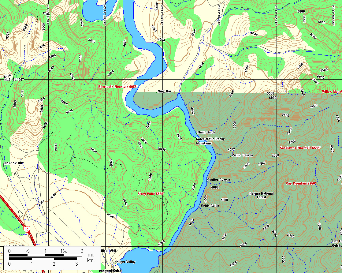 |
Scroll to the right to see the full display. The Gates of the Rocky Mountains are shown as a red dot.
 Digitized contours at the 100 foot contour interval level. |
 Triangulated Irregular Network made from digitized contours. |
 Missouri River superimposed in light cyan. |
 The Gates of the Rocky Mountains, red dot. |
Each
type of base topographic map has merits: the 1000 foot contour
interval
map is useful, especially when represented as a TIN, as a general
context
map. When the finest contour interval (10 feet) was used, the
general
context was not evident. The TIN derived from the contour base
shows
great detail. The 100 foot contour interval offers a balance
between
the two. That map, however, was not a digitized map that would
work
directly in a GIS (ArcView, ESRI). Thus, the contours were
digitized
from the 100 foot base map, a TIN created from that base, and then the
TIN was put into ArcView 3D Analyst extension (ESRI) and saved as VRML
2.0, as a virtual reality of the scene. The much more highly
detailed
USGS file renders a fine virtual reality scene; however, the size of
that
file is over 177 MB and it causes many machines to crash. Thus,
the
more modest file of 3 MB created from the 100 foot contour interval map
is included here. Readers should download (free) Cosmo Player from http://ca.com/cosmo/
in order to view the virtual reality files directly in their internet
browser.
| Click here
to see an animation of contours with superimposed TIN; The Gates of the
Rocky Mountains are shown as a red dot.
Click here to see the virtual reality scene of "The Gates of the Rocky Mountains" derived from the 100 foot contour interval. |
What
else might illuminate historical and geographical texts of the future,
as an exploration in imaginative interactive communication and
education?
One
might envision
- creating routes and scenes, defined by the user, in support of text. (See, for example, the outstanding display created at the Department of Geography, University of Missouri in the attached link)
- taking virtual voyages in canoes up the Missouri River as a search (using a search function) of the landscape for animated local sentinels, all while music of the period is playing in the background.
- creating a virtual Mandan village, as a way for present day Americans to view one of the most important trading communities of the period.
DeLorme, Topographic Atlas on CD. http://www.delorme.com/
DeVoto, Bernard. The Journals of Lewis and Clark with a foreword by Stephen E. Ambrose, maps by Erwin Raisz. Mariner Books, Houghton Mifflin Company (Boston and New York), original copyright 1953; current version, 1997.
Digital Chart of the World. Environmental Systems Research Institute, http://www.esri.com/.
Lewis and Clark Across Missouri, http://lewisclark.geog.missouri.edu/index.shtml
USGS, EROS Data Center, http://edc.usgs.gov/geodata/